Voyager America
Heading into the last stop in America....
Big Bend National Park and Big Bend State Park, Texas
I came through Big Bend country 40 years ago. I was rolling toward Colorado with Jesse Rettstadt to see friends. Once we hit Fort Stockton, Texas, and headed south to Big Bend, it felt and seemed like we were in absolutely empty land, heading to the edge of the earth. There were no phone/electric poles along the roads, no fences, no houses or buildings of any kind, only arid landscapes with distant, hazy mountains. The Big Bend region was the same: Terlinqua was a true ghost town with two rows of abandoned buildings and four-foot high wooden sidewalks. One of the abandoned shops was home to Far Flung Adventures, the local rafting company that would take you through the Santa Elena Canyon. Lajitas had one general store and a few homes. David
 |
Ocotillo...beautiful, graceful plant that is everywhere
throughout Big Bend....a true survivor in the desert.
|
 |
The landscape is vast and just goes on and on and on.
|
Big Bend is BIG. It is really bigger than big. It is immense and its immensity is difficult to comprehend. Your eyes see forever across vast desert expanses dotted with scrub bush, ocotillo and prickly pear cactus that define the landscape. This diverse place is home to 1,500 types of plants that thrive in the park and support ecosystems full of pollinators, herbivores and varied wildlife including bears, bobcat and mountain lions....which unfortunately we did not see. As you climb through massive canyons up into the mountains their immensity is equally hard to understand and put into perspective. Unfortunately, no camera can capture this. Big Bend National Park is way out at the southern tip of Texas where the Rio Grande River cuts a huge bend in the land between Mexico and the United States. It is actually named for the 90 degree turn in the course of the Rio Grande near the souther tip of the park. It is not a very wide river, but it has been a mighty force for centuries and is ever-changing to this day.
 |
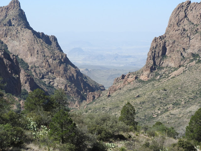
| "The Window" looking from the Chisos Mountains to the desert below. |
 |
| The Chisos Mountains campground is a great spot to bird. |
Big Bend is famous for its birding, with more documented species of birds visiting the park throughout the year than any other park in the National Park system (approximately 450). The park's diverse array of habitats ranging from the riparian corridor of the Rio Grande to the forested canyons of the Chisos Mountains provide an attractive stopping point for birds traveling along their major migratory routes that intersect the park.
 |
The energetic Roadrunner is rarely still.
|
 |
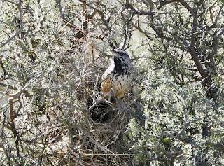
| Cactus Wren in Chisos Basin Campground. |
 |
Cactus Wren emerging from her nest.
|
 |
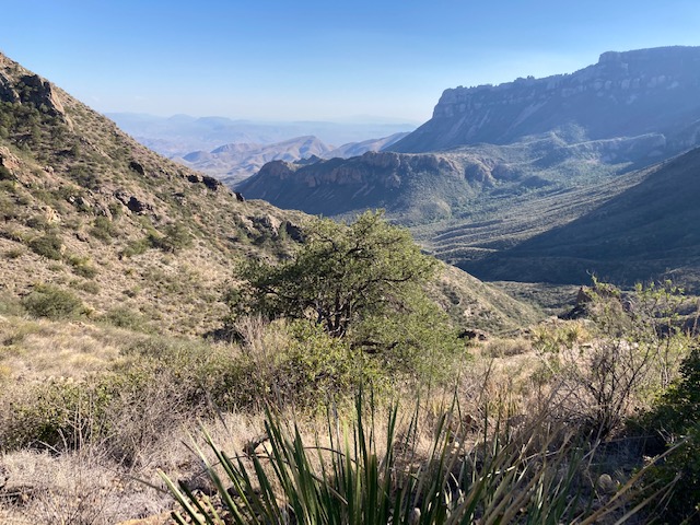
The Lost Mine Trail.....one of our favorites with breathtaking views!
|
 |
On The Lost Mine trail.
|
 |
Santa Elena Canyon....a popular rafting and kayak trip.
The canyon walls here are 1500 feet high. A breathtaking spot. |
Today, a golf resort stands on top of where the Lajitas General Store stood 40 years ago. There is a small airport so golfers can fly here to tee off. The mayor of Lajitas is a goat...yes this is not a typo. Clay Henry is his name and he and a partner live in a big cage outside the new convenient store.
Terlinqua, just outside Big Bend, has restaurants and shops in the "ghost town" and one whole side of the town's buildings have been torn down. The Terlinqua Cemetery looks much the same, but with a new fence, explanatory signage, and an arched entrance. The cemetery dates from the early 1900's when Terlingua became a flourishing mercury mining town. It served the district as the final resting place for residents and mine workers that succumbed to dangerous working conditions, gunfights and the influenza epidemic of 1918.
Accommodations were hard to find in Terlingua on this trip. We did find tent site availability at Basecamp Terlingua, a fairly new and very hip place that offered tent sites, tipis, lotus tents and pods (not sure what the pods are). Our campsite had running water and electricity on site, and just up the hill are great showers, bathrooms and a coffee room complete with a Keurig machine. Very nice for a campground. Two of the three nights we camped there were very cold....30 degrees, with the day temperatures around 90. A sixty degree drop in temperature was a jolt to the body, but we slept in hats and layers of clothes in our sleeping bags and came through those nights just fine.
All along the road from Terlinqua to Lajitas are rafting businesses, restaurants, and places to stay. The change has been dramatic, but thankfully it still remains so far away from "the rest of the world". The land down here, dominated by Big Bend National Park and Big Bend State Park is immense, strong, at times harsh, beautiful beyond belief, where magic and myth still speak loudly.
 |
World Famous Clay Henry, Mayor of Lajitas. Look closely into the cage and you can see Clay
sleeping on the pile of stones in the front and his partner looking on in the back. |
 |
Along the road in Terlingua.
|
 |
| Basecamp Terlingua |
 |
Terlingua Cemetery celebrating lives in many
interesting and wonderful ways.
|
 |
A much overlooked park living in the shadow of the national park we were told, Big Bend State Park occupies vast areas of land and mountains just to the west of Big Bend National Park. It has been a popular filming location for numerous western movies such as Streets of Laredo and Fandango.
|
 |
It was a cold and windy day in Big Bend State Park.
|
 |
Sunset in Big Bend National Park.
|


Wonderful photos and descriptions of Big Bend. What a perfect time to be on the road seeing the beauty of the land. I never realized or maybe I forgot that David had Texas roots. Revisits to the places of our youth is always a combination of wonderful and bittersweet memories. Please keep posting. I'm actually quite talented at living vicariously. Stay safe you two. Love Rhonda
ReplyDeleteKeep going!
ReplyDelete